Download Geography Notes PDF: The Earth, Latitude & Longitude from Parmar SSC Fatman + Lucent. Useful for SSC, Railway, WBCS, UPSC, and other competitive exams.
THE EARTH
Shape of Earth
• Shape of Earth is Geoid or Oblate Spheroid (a little flat from top and bottom) and bulged at the centre.
• Reason: Centrifugal force (due to rotation of Earth).
Radius of Earth
• Equatorial radius: 6378 km
• Polar radius: 6357 km
• Mean radius: 6371 km
Circumference of Earth
• Polar: 40,007.863 km
• Equatorial: 40,075 km
• Mean: 40,040 km
• Equatorial speed > Polar speed
• Equatorial radius > Polar radius
• Equatorial circumference > Polar circumference
• (All because the Earth is bulged at the equator and flattened at the poles)
• 23½° N – Tropic of Cancer
Rotation of Earth
• Earth rotates on its own axis from West to East (Anticlockwise).
• One rotation of Earth = 23 hours 56 minutes 4 seconds
• Rotational speed is maximum at the Equator and minimum at the Poles.
• Day and night are caused by the Earth’s rotation on its axis.
Revolution of Earth
• Earth revolves around the Sun in elliptical orbit.
• One revolution = 365 days 6 hours 9 minutes and 9 seconds
• Orbital speed = 29.8 km/sec
• Mercury has the maximum orbital speed.
• Neptune has the minimum orbital speed.
• The Earth’s revolution around the Sun and the tilt of its axis cause the seasons.
Distance of Earth from Sun and Moon
Sun
• The point in a planet’s orbit when it is closest to the Sun is called Perihelion.
• On January 3rd, the Earth is nearest to the Sun (147 million km).
• The point in a planet’s orbit when it is farthest from the Sun is called Aphelion.
• On July 4th, the Earth is farthest from the Sun (152 million km).
Moon
• The point in the Moon’s orbit when it is closest to Earth is called Perigee.
• At Perigee, the Moon appears larger in the sky.
• The point in the Moon’s orbit when it is farthest from Earth is called Apogee.
• At Apogee, the Moon’s tide-raising force is smaller and the tidal ranges are less than average.
Inclination of Earth’s Axis
• Axial inclination = 23½°
• Orbital inclination = 66½°
LATITUDE AND LONGITUDE
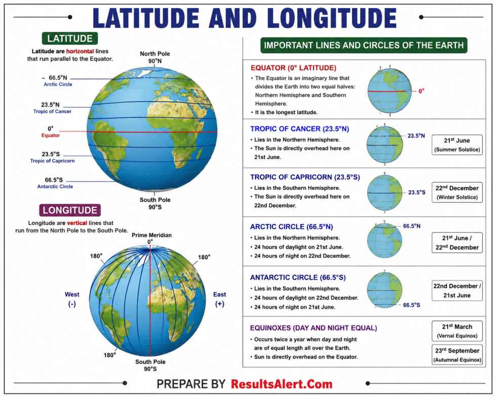
Latitude
• They are imaginary horizontal lines on the globe that run from East to West.
• It is the angular distance of a place from the Equator.
• Total latitudes = 181
• Distance between each latitude is same.
• 1° of latitude = 111 km
Important Latitudes
• 0° – Equator (divides Earth into Northern and Southern Hemisphere)
• 23½° N – Tropic of Cancer
• 66½° N – Arctic Circle
• 23½° S – Tropic of Capricorn
• 66½° S – Antarctic Circle
• All parallel circles from the Equator to the Poles are known as Parallels of Latitude.
• Largest latitude: Equator
• Smallest latitude: Poles
Longitude
• They are imaginary vertical lines on the globe that run North to South.
• Distance between each longitude decreases from Equator towards Poles.
• At the Poles it is 0, while it is maximum at the Equator (111.32 km).
• Total longitudes = 360
Important Meridians (Longitudes)
• Prime Meridian = 0° Longitude (passes through Greenwich, London)
• International Date Line = 180° Meridian
• Prime Meridian is also known as International Meridian or Greenwich Meridian.
It passes through:
• Burkina Faso
• Spain
• France
• Ghana
• Algeria
• Mali
• Togo
• United Kingdom (UK)
Trick to Remember
BSF GAme in TOGO KINGDOM
Concept of Time Using Longitude
• 360° = 24 hours
• 15° = 1 hour
• 1° = 4 minutes
• Earth rotates 15° in 1 hour.
• Earth rotates 1° in 4 minutes.
• Moving East from Prime Meridian, time increases by 1 hour for every 15°.
• Moving West from Prime Meridian, time decreases by 1 hour for every 15°.
Time Zones
• Entire Earth is divided into 24 Time Zones.
• France has the most number of Time Zones (13).
• Russia has 11 Time Zones.
• USA has 6 Time Zones.
Isochrones
• Lines joining points located at equal travel time from a common centre.
International Date Line (180° E/W)
• It is the imaginary zig-zag line passing through the Pacific Ocean from where the date changes.
• Crossing eastbound (Japan to USA), the date is subtracted by 1 day.
• A person gains a day and vice versa.
Concept of Great Circle
• A Great Circle is the largest possible circle that can be drawn around a sphere.
• It divides the Earth into two equal hemispheres.
• All longitudes are Great Circles.
• Equator is the only latitude that is a Great Circle.
Uses of Latitude
Climatology
• Temperature zones
• Wind pressure system
• Planetary wind system
Location of Place
• Hemisphere identification
• Equal division of Earth into two parts
Hemisphere
• Equator divides the globe horizontally into Northern and Southern Hemisphere.
• Prime Meridian divides the globe vertically into Eastern and Western Hemisphere.
SOLSTICE AND EQUINOX
Solstice
• A solstice occurs when the Sun reaches its highest or lowest point in the sky, resulting in the longest or shortest day of the year.
Summer Solstice
• Occurs on 21st June
• Longest day of the year in Northern Hemisphere
• Sun’s vertical rays fall on Tropic of Cancer
• Northern Hemisphere gets more heat
• Continuous sunlight on North Pole for 6 months
Winter Solstice
• Occurs on 22nd December
• Shortest day and longest night in Northern Hemisphere
• Sun’s vertical rays fall on Tropic of Capricorn
• Southern Hemisphere gets more heat
• Continuous sunlight on South Pole for 6 months
Equinox
• Day and night are approximately equal.
• Neither pole is tilted towards the Sun.
• Vernal (Spring) Equinox – 21st March
• Autumnal (Fall) Equinox – 23rd September
ECLIPSES
Solar Eclipse
• Moon comes between Earth and Sun.
• Shadow falls on Earth.
• Occurs during New Moon (Amavasya).
Lunar Eclipse
• Earth comes between Sun and Moon.
• Shadow falls on Moon.
• Occurs during Full Moon (Purnima).
Red Moon
• Earth’s atmosphere scatters blue light and allows red light to reach the Moon.
Blue Moon
• Two Full Moons within a single calendar month.
Types of Solar Eclipse
• Partial Eclipse
• Annular Eclipse
• Total Eclipse
Supermoon
• Occurs when the Moon is closest to Earth during a Full Moon.
• Moon appears larger than normal.
Syzygy
• Alignment of Sun, Moon and Earth in a straight line.
TORRID, TEMPERATE AND FRIGID ZONES
Torrid Zone
• Hottest zone of Earth.
• Receives direct overhead rays of the Sun.
• Located between Tropic of Cancer and Tropic of Capricorn.
Temperate Zone
• Located between Tropic of Cancer and Arctic Circle.
• Located between Tropic of Capricorn and Antarctic Circle.
• Receives slanting rays of the Sun.
Frigid Zone
• Coldest region of Earth.
• Experiences 6 months day and 6 months night.
• Located beyond Arctic Circle (66½° N).
• Located beyond Antarctic Circle (66½° S).
TIDES
Tides
• Periodic rise and fall of ocean water levels.
• Caused by gravitational pull of the Moon and the Sun.
• Two types of tides.
Neap Tides
• Earth, Moon and Sun are in perpendicular alignment.
• Lower tidal range.
Spring Tides
• Earth, Moon and Sun are aligned in a straight line.
• Higher tidal range.